A Geographical Information System (GIS) is designed to capture, store, manipulate, analyse, manage and present spatial or geographic data. In other words, the data is in some way related to geographical locations. The use of artificial intelligence in conjunction with GIS has had a great impact on traffic management, ride sharing, etc. Let’s look at some other applications.
Over the years, artificial intelligence (AI) has become a buzzword that symbolises the next stage of innovative technological transformations and how industry will be driven in the future. Using intelligent algorithms, data classification and smart predictive analysis, AI can be used in a number of sectors ranging from healthcare, finance, advertising and retail, to manufacturing and transport. During the last ten years, machine learning and AI have been rapidly transforming many areas related to GIS and spatial applications. Artificial intelligence provides sophisticated techniques for GIS projects, while GIS is a powerful technology with vast data sets and wide scope for the use of AI. For example, fuzzy logic has been successfully applied to imprecise spatial issues like data collection, representation and analysis as well as for the classification of land, soil and remotely sensed imagery.
Machine learning and artificial intelligence in GIS
Technologies like AI, deep learning and machine learning (ML) have matured just in time to equip us with the tools we need to make sense of an ever-increasing trove of imagery data in the context of GIS. Simply put, ML makes sense out of noisy data, finding patterns that you’d never think existed. It empowers the geospatial ecosystem by providing real-time near-human level perception, integrates into analytical workflows, and drives data exploration and visualisation. It thus automates the entire process of creating scalable insights from large amounts of data. In other words, it is software that writes software. Instead of applying a pre-built function, ML gains experience through repeatedly seen/experienced conditions and builds a model that can be applied in a new situation. Such machines are able to understand geospatial information, and with deep learning, they are able to obtain geospatial information from their surroundings, as required, and process it in real-time to do their jobs. For example, Google might use Bayesian classification to filter spam emails. Alternatively, Facebook might use it for facial recognition and automatically identify faces in images.
Types of machine learning
The two broad categories of machine learning that can apply to GIS applications in various ways are supervised and unsupervised learning.
Supervised learning, in the context of AI and ML, is a system in which both the input and the desired output data are provided. For example, if you plot millions of sample points in a graph, you can fit a line to approximate a function. Supervised learning systems are mostly associated with retrieval-based AI but they may also be capable of using a generative learning model.
Unsupervised learning is the training of an AI algorithm using information that is neither classified nor labelled and allowing the algorithm to act on that information without guidance. So, when Facebook wants to find out the exact geographical locations where people do not have access to the Internet, all it needs to do is take 350TB of satellite imagery and run it through an AI-enhanced image-recognition engine. After processing 14.6 billion pictures, Facebook will be able to identify more than 2 billion disconnected people across 20 countries.
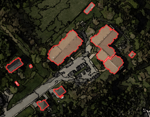
Artificial intelligence is applied to GIS in areas such as image classification, prediction and segmentation.
Image classification using Support Vector Machine
When you look at a satellite image, it’s not always easy to know whether you are looking at trees or grass, at roads or at buildings. So imagine how difficult it would be for a computer to differentiate between these.
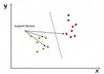
Support Vector Machine (SVM) is a machine learning technique that takes classified data and looks at the extremes. It is a discriminative classifier formally defined by drawing a decision boundary line based on the data called a hyperplane. The data points that the hyperplane margin pushes up against are the support vectors.
Support vectors are important because they are the data points closest to the opposing classes and all other training points can be ignored in the model. When you feed SVM the training data samples of trees and grass, it builds the model, generating a decision boundary of its own. But the results of this supervised classification aren’t perfect and algorithms still have a lot more learning to do. They still need to work on features like roads, wetlands and buildings. As algorithms get more training data, they will eventually improve the classification.
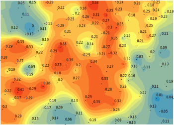
Image prediction using Empirical Bayesian Kriging (EBK)
Geostatistics is the generic name for a family of techniques that is used for the mapping of surfaces from limited sample data and the estimation of values at unsampled locations. Geostatistical estimation is a two-stage process:
i. Studying the gathered data to establish the predictability of values from place to place (locations) in the study area, which results in a graph known as a semi-variogram.
ii. The process of estimating values at those locations that have not been sampled is known as kriging. The basic kriging technique uses a weighted average of neighbouring samples to estimate the unknown value at a given location. It estimates weights based on the variogram. And the quality of the estimated surface is reflected in the quality of the weights. More specifically, you want weights that give an unbiased prediction and the smallest variance.
Unlike kriging that fits one whole model for an entire data set, Empirical Bayesian Kriging (EBK) simulates at least one hundred local models by sub-setting the whole data set. Because the model can morph itself locally to fit each individual semi-variogram using kriging methodology, it overcomes the challenge of stationarity. Each semi-variogram varies from each other. In the end, it mixes all the semi-variograms for a final surface. You can see the trends in the resulting data and use that to justify your selection.
Image segmentation and clustering with K-means
By far, the K-means clustering algorithm is one of the most popular methods of clustering data. This is an unsupervised algorithm and is used to segment the interest area from the unlabelled data into the number of groups represented by the variable K. But before applying the K-means algorithm, the first partial stretching enhancement is applied to the image to improve its quality. The algorithm iteratively assigns each data point into one of the K groupings, based on a similarity of features. For example, similarity can be based on spectral characteristics and location. In an unsupervised classification, the K-means algorithm first segments the image for further analysis. Next, each cluster is assigned a land cover class.
However, GIS can use clustering in other unique ways. For example, it can be used for crime mapping—the data points could represent crime locations that can be clustered as spots of crime.
AI applications in GIS
The applications of artificial intelligence in GIS are in a number of sectors, including those that use location and GIS. Ride-sharing companies, logistics, agriculture, surveying, and infrastructure are some of the prominent examples.
Predictions and remote monitoring: AI based GIS applications can handle complex weather and climate imagery data patterns that humans can’t process on a large scale and in real-time. Such GIS applications can result in solutions for problems arising from climate change, air pollution, water pollution and forest management. This framework can optimise the use of land data, agriculture data, regional based crop data, etc, to maximise the economic benefits for society.
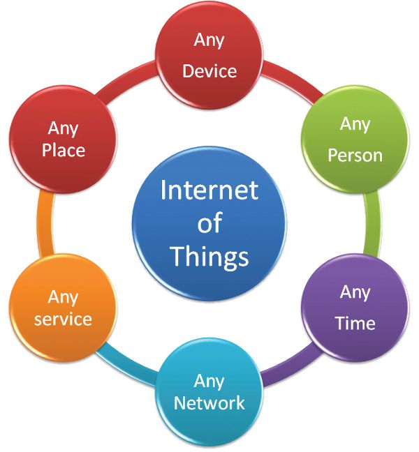
Internet of Things (IoT): Almost every connected device that uses GIS application software can use artificial intelligence as a platform to predict, adapt, learn and make decisions for end users. The neural geospatial data system can be the core engine for self-driving vehicles and drones to adapt and manipulate an environment in real-time, using all kinds of GIS data.
Geographic consumer behaviour: In today’s competitive world, understanding the consumer is the focus of any organisation. AI based structures can learn and predict consumer behaviour using geographic data and come up with specialised regional solutions. Ride-sharing companies like Uber, Ola, etc, can take feedback from customers and process the data to find out the density of cars and the availability of drivers. In logistics and supply chains, artificial intelligence can plug the gaps and gather more accurate location information that can streamline product delivery and save time.
Overall, in the realm of business, artificial intelligence based systems can create an ecosystem around various GIS applications that would substantially improve planning, resource allocation and decision-making – predicting the surge in demand and supply, identifying the prospects of high and low margins, multiplying supply chain efficiency, and optimising service delivery. The scope is endless.


